A layer is comprised of components. There are multiple kinds of components, each with their own representation on the Geochron Digital.
By combining these basic components together, and by providing the right assets, some advanced layers can be created and sent to your Geochron without any programming! More sophisticated or interactive layers can be created if you're willing to write some code, too.
Point Component
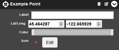
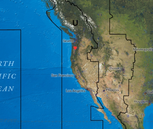
A Point component is similar to a custom pin. It can be placed at a given latitude and longitude, can optionally have a custom icon, and can have a color and a label.
Properties
- Label: This label will appear above and to the right of the point on the map.
- Lat/Long: Latitude and longitude at which the point should appear on the map
- Color: The color the point and its associated text should be
- Icon: If unset, a circle matching the point's color will be used. If set, the icon will display instead.
Path Component
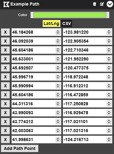
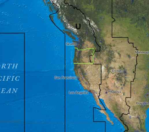
A path is a line drawn on the map by providing a series of latitude and longitude coordinates.
Properties
- Color: This label will appear above and to the right of the point on the map.
- Points: Each lat/long pair in this list will be used as a "stop" in the path, drawing out the overall shape on the map.
- Add Path Point: Add another lat/long pair to the list, effectively extending the length of the path.
Overlay Component
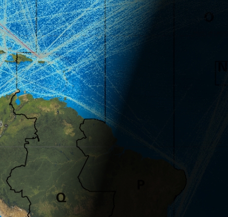
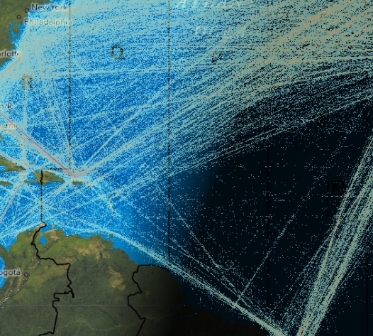
An overlay is a full-size image spread out over the whole map. Transparent parts of the image will reveal the map - and other layers - underneath it.
An "underlay" is a special kind of overlay that is placed below the "night" portion of the map, so it is darkened by the night like the mapset itself is.
Properties
-
Position: This setting determines where the overlay is placed relative to the "shadow" of night on the Geochron map.
- Under Night: The overlay will be drawn underneath the shadow of the planet, darkening the overlay in places where it's dark.
- Over Night: The overlay will be drawn over the shadow of night, remaining the same brightness regardless of time of day at that spot of the map.
- Image: Upload an image or set a URL to an image here. The image will be stretched over the whole world, so it should be constrained to a Mercator projection matching our latitude/longitude limits.
Legend Component
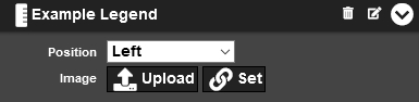
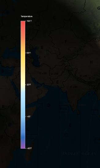
A Legend lives in one of the legend containers and is typically used to provide scales for overlays or other data, but can also be used standalone as a method to present fixed-position information not correlated to another component.
Properties
-
Position: This setting determines where the overlay is placed relative to the "shadow" of night on the Geochron map.
- Top Left: A corner-of-screen legend space useful for small legends. Stacks from the top down.
- Top: A small, thin legend container at the top of the screen - useful for text captions or thin legend bars. Stacks from the top down.
- Top Right: A corner-of-screen legend space useful for small legends. Stacks from the top down.
- Right: A large legend container along the left side of the map, aligning with the 'left' midnight line. Stacks from the right to the left.
- Bottom Right: A smaller corner-of-screen legend space useful for small legends. Stacks from the bottom up.
- Bottom Left: A smaller corner-of-screen legend space useful for small legends. Stacks from the bottom up.
- Left: A large legend container along the left side of the map, aligning with the 'left' midnight line. Stacks from the left to the right.
- Image: Upload an image or set a URL to an image here. The image will be proportionally resized to fit the container, but if it can't, it will be ignored.
Legend Containers
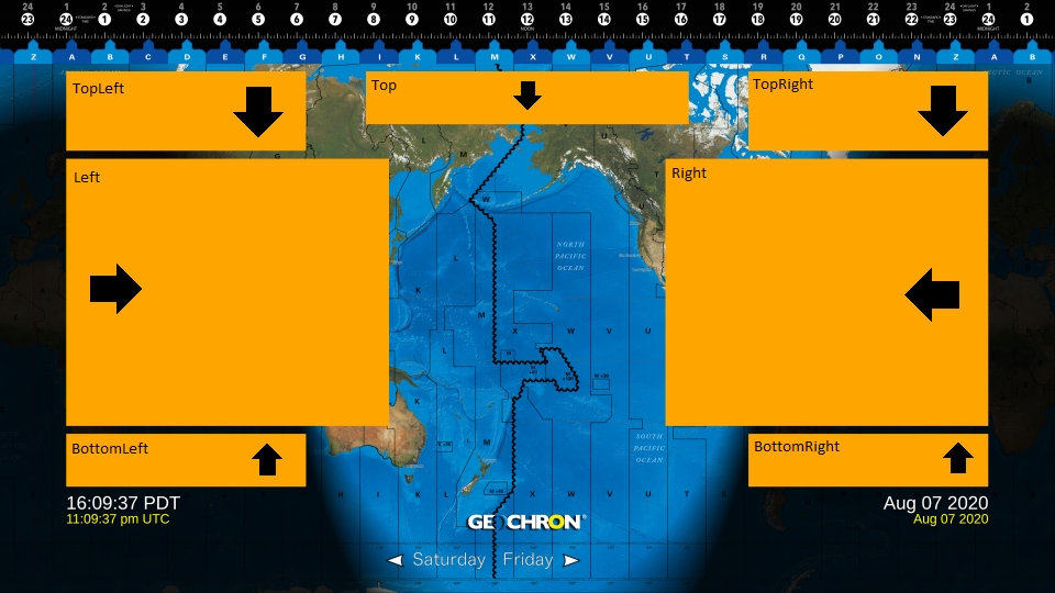
Legends live inside of containers that are placed at fixed locations on the Geochron Digital. Each container has a maximum size of supported legend, and anything larger will be reduced to fit within it (if proportionally possible).
A container will have a certain "stacking direction", so that when multiple legends are placed within the same container, they are stacked (as space permits) along a given axis. If a legend container runs out of space, the oldest legend will be removed first.
Orbital Component
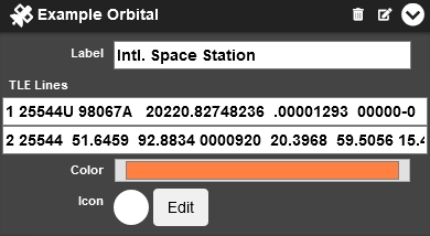
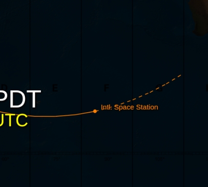
An Orbital represents an orbiting element given in the form of a Two-Line Element (TLE) set, which is a standard method of representing orbital components. A trail is drawn representing its previous motion, and a point is given at its current location.
Optionally, speed and altitude information is displayed, and a trail indicating its future location is presented.
Properties
- Label: This label will appear above and to the right of the orbital item on the map.
- TLE1: The first line of a Two-Line Element (TLE) orbital description.
- TLE2: The second line of a Two-Line Element (TLE) orbital description.
- Color: The color the orbital and its associated text should be
- Icon: If unset, a circle matching the orbital's color will be used. If set, the icon will display instead.
Location Component
A Location accepts a location designation of some form (currently only Postal Code) and resolves it to a Lat/Lng Point component for display on the Geochron Digital.
Properties
- Label: This label will appear above and to the right of the point on the map.
- Type: What type of location look-up to perform. Currently only supports "PostalCode".
- Data: Location look-up data. Currently only supports postal codes.
- Color: The color the point and its associated text should be
- Icon: If unset, a circle matching the point's color will be used. If set, the icon will display instead.
Advanced Components
Advanced components will probably require some kind of programming to use them effectively. They allow you to create more sophisticated layers, though.
Http Component
An Http component will regularly attempt to fetch data from a specified Fetch URL and pass it along to a renderer (specified by the Render URL) when the data changes. The renderer will be given a call-back URL to the API server, where it will send the result of its work. The provided rendered output will then be sent to the client device as an overlay or legend.
Csv Component
A CSV type accepts CSV data and outputs corresponding components. Each row of a CSV corresponds to an output component of one of the other (above) types.
The purpose of the CSV type is to allow for an easier export of data from other programs or locations. CSV files are much easier to interact with than our custom JSON REST API, so it might be easier to manually upload new data as you receive it than interact directly with our API's component functions.